
A Geozone is a designated geographical area that a user creates and is saved to the organization’s web portal. Creating a Geozone is a function available to the users with the Super Administrator, or the Geozone Administrator role in your organization’s Navistream web client.
Once created, all users with access to fleet tracking can see the zone but only the admin users can create more or edit existing ones.
Geozones are important for tracking information in defined specific areas, and will grant data access on Driving Time, Driving Distance, Fuel Consumption*, Stoppage Time, Idle Time*, Tire Pressure**, and Total Time.
*This data is only available for vehicles outfitted with ECM integrated systems.
**This data is only available for vehicles outfitted with TPMS-VGM integrated systems.
Where to Create a Geozone
Log into a user account with either the Super Administrator or the Geozone Administrator Role
If you have the Geozone Administrator role you will either have the Dispatcher Role, or the Administrator role. This will affect where you are able to interact with Geozones either through Fleet Tracking, or Locations.
Under Fleet Tracking: Select “+ New Geozone” located on the top center of the map.

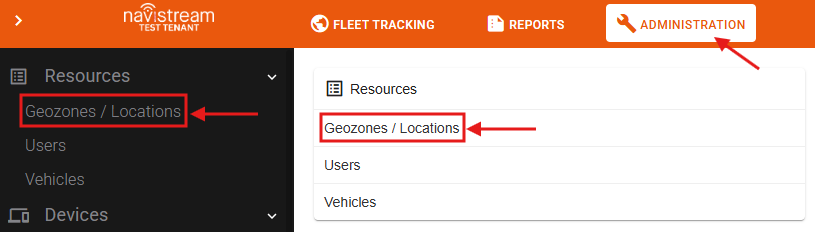
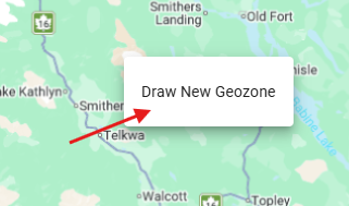
Under Administration: Select the "Geozones/ Locations" options from the "Resources" list either on the middle of the screen or the left side menu. Then, Right-Click on the Map and select “Draw New Geozone”.
How to Create a Geozone
Left-Click to place a point on the map.
Continue placing points on the map to create a polygonal shape to outline your desired Geozone.
After you’ve clicked back onto your original point, the Geozone will be completed and a pop-up menu will appear (If under Administration, you have to click “Save” on the map to be directed to the pop-up menu).
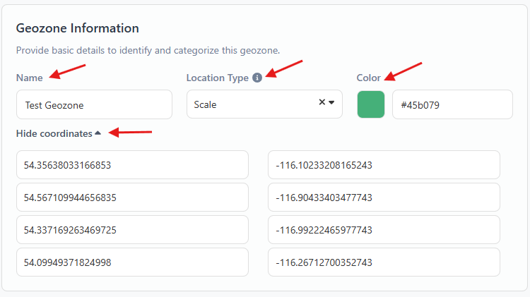
Use this menu to give your Geozone a Name, Location Type, Display Color, Speed Limit and Grace Period, or to edit your exact coordinates.
Name: Name of Geozone.
Location Type: Choose the most relevant choice from the list.
Display Color: Your Geozone will appear in this color on the map.
Coordinates: The exact coordinates of your drawn polygonal shape with the ability to edit them more accurately.
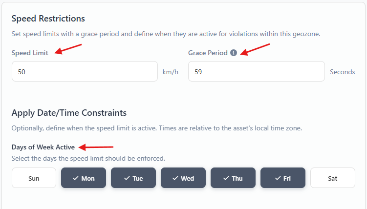
Speed Limit: Designate a max speed limit for any vehicle in this Geozone.
Grace period: After going over your designated speed limit for a time greater than the designated Grace Period (Unit is in Seconds) a speed violation will be recorded.
Date/ Time Constraints: You also have the ability to enforce the restriction on the set Speed Limit's Days of the Week, Time of Day, and Date Ranges.
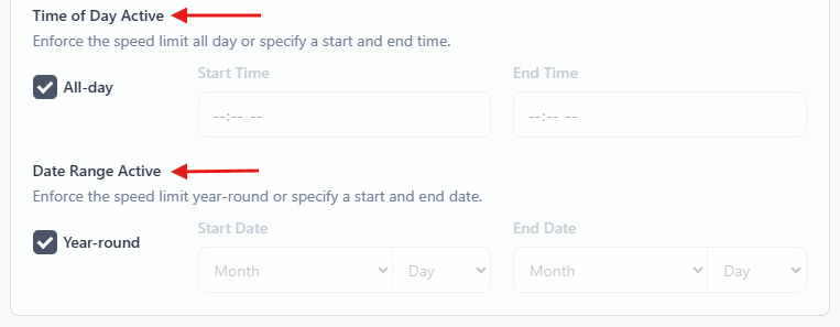
- Press the Save button when finished.
The picture below shows what a Geozone looks like after being created.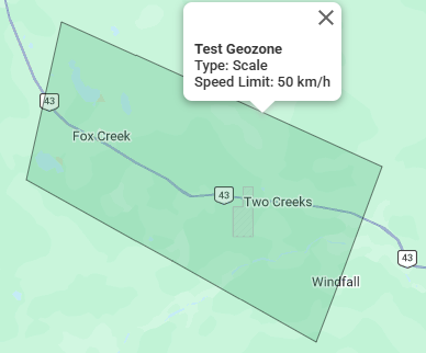
How to edit an already existing Geozone
Fleet Tracking
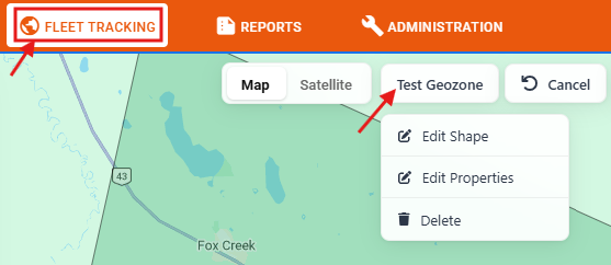
Find the Geozone on the map and left click on it.
The name of the Geozone will appear with a map pointer in the top center of the map area.
Hover your mouse over the name to bring up available options
Edit Shape: Select this option to edit the shape of the Geozone.
Edit Properties: Select this option to edit the properties.
Delete: Select this option to delete the Geozone.
Administration
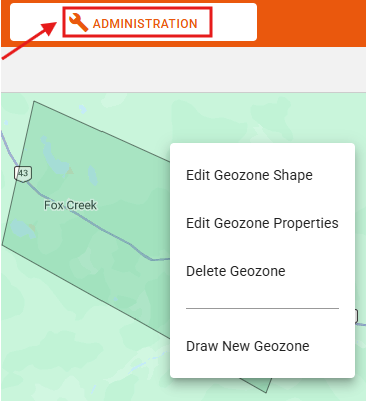
Find Geozone on the map and right-click on it.
A new window will appear with the following options
Edit Geozone Shape: Select this option to edit the shape of the Geozone.
Edit Geozone Properties: Select this option option to edit the properties.
Delete Geozone: Select this option to delete the Geozone.
Draw New Geozone: Select this option to create a new Geozone.
Under Administration, you also have the ability to search for a Geozone by Name, Type, Speed Limit, Grace Period, Tire Pressure, Grace Distance, and Color Code. Selecting the searched Geozone will direct you to it's location on the map.

Notes:
Tracking of vehicle data is automatic once a Geozone is established.
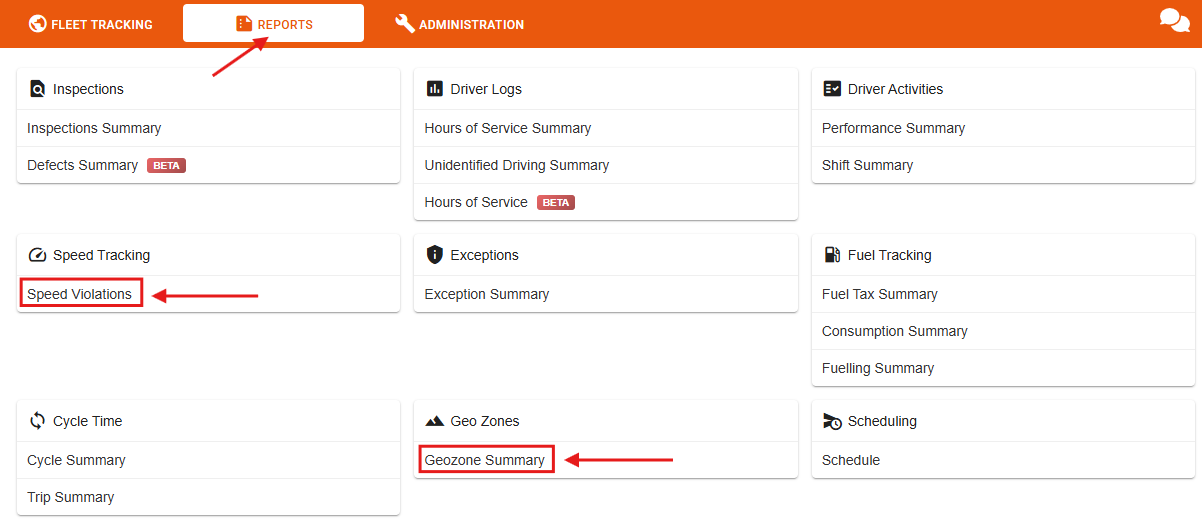
You can pull up data or reports on your created Geozones by clicking the "Geozone Summary" report on the "Reports" menu.
Reports on speed violations tracked by Geozones are also available on the "Speed Violations" report on the "Reports" menu.
If you have any questions about Creating or Editing a Geozone, please contact Navistream Support.
Navistream Support
1(844)571-8200 Ext 2